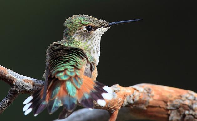
Birds in This Story
Pectoral Sandpiper
Latin: Calidris melanotos

American Golden-Plover
Latin: Pluvialis dominica

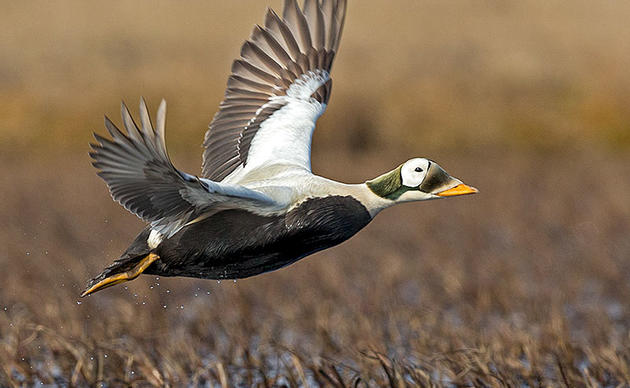
Yellow-billed Loon
Latin: Gavia adamsii

Spectacled Eider
Latin: Somateria fischeri

Steller's Eider
Latin: Polysticta stelleri

Dunlin
Latin: Calidris alpina

For those of us who aren’t geotechnical specialists, the term “seismic exploration” can be alternately cryptic, confusing, or simply call to mind a geological journey à la Jules Verne or Ms. Frizzle’s Magic School Bus. But for those in the know, seismic can sometimes translate to sizeable profit margins or, unfortunately, irreversible ecological scarring.
The stakes here are serious, so it’s worth wading through some messy details to make sense of this recurring issue.

What Is Seismic?
Simply put, a seismic survey or seismic testing means sending sound waves deep underground and measuring how long it takes for them to bounce back. An immediate bounce-back means relatively solid rock, right underfoot. If it takes longer for a discernible reflection to return, the sound wave traveled further before hitting something solid. By measuring multiple layers of bounce-backs at various depths, surveyors can identify not only chunks of solid rock but also the gaps between layers of solid rock that may contain oil-filled reservoirs. It’s a widely used tool in all sorts of geological research and has become ubiquitous on Alaska’s North Slope as oil companies drill through public land trying to find the hydrocarbons underneath.
The word seismic comes from the Greek “seismos,” which means “to shake.” The etymology (study of word origins) gives you an indication of the physical forces at work here: Seismic surveys require sending enormous amounts of energy into the earth, enough to pulse through thousands of feet of solid rock and still have enough energy to reverberate back to the instruments on the surface.
During the early days of seismic surveys—the 1920s—geologists would detonate dynamite to generate sufficient force. Newer arrays use massive “thumper trucks,” which slam down a metal hammer weighing several tons into the ground, again and again. To tow these vibrator units—as well as the recording apparatus, associated equipment, personnel, mobile camps, and fuel it all requires—oil and gas companies typically use D-7 Caterpillar bulldozers, which weigh about 15 times as much as a Toyota Tacoma. This heavy-duty caravan can sprawl to over 50 vehicles, slowly lurching across hundreds of miles of tundra, pounding the ground as they go.
The next push to get this machinery onto the tundra is already underway, as leaseholders ConocoPhillips and the Alaska Industrial Development and Export Authority (AIDEA) are actively moving forward with plans for seismic testing— the first step toward oil and gas development—in America’s Arctic as soon as this winter.

Where Is This Happening?
Seismic testing is slated for two regions in northern Alaska: The Arctic National Wildlife Refuge (Arctic Refuge) and the National Petroleum Reserve–Alaska (NPR–A or, simply, “the Reserve”). Both regions are home to some of the most biologically, ecologically, and culturally significant public lands in the country. They are also both considered some of the most remote landscapes in the United States. Perhaps out of sight, but not out of mind.
The 23-million-acre Reserve is considered one of the most remote landscapes in the United States. Despite being named as a petroleum reserve in 1976, Congress directed the Department of the Interior, specifically the Bureau of Land Management, to manage the Reserve and provide “maximum protection” for areas that hold “significant subsistence, recreational, fish and wildlife, or historical or scenic value.”
Indeed, the Reserve provides critical habitat for millions of migratory birds from six continents, including species of conservation concern like the Spectacled and Steller’s eiders and the Yellow-billed Loon. Birds from the Reserve and across the Western Arctic disperse along all four major flyways of the United States, as well as to Asia and beyond. The Reserve’s coastal areas offer maternal, vital denning grounds for polar bears and resting areas for walruses and seals. Its rivers and lakes support fish like Arctic char and whitefish—foundational links of both the food web and the diet of subsistence communities. It provides irreplaceable calving habitat for two caribou herds, including the Western Arctic Caribou Herd, one of the largest caribou herds in the world.
Within the Reserve, five areas have been specially identified for “maximum protection:” the Utukok Uplands, Kasegaluk Lagoon, Colville River, Peard Bay, and Teshekpuk Lake. Teshekpuk teems with birds and alone is one of the most ecologically important wetlands in the entire Arctic. This “Special Area” is a haven for about 100,000 molting geese, swans, and ducks, which are then traditionally hunted in Alaska and elsewhere. Teshekpuk hosts exceptionally high densities of breeding shorebirds, including substantial proportions of populations of American Golden-Plover, Pectoral Sandpiper, Dunlin, and other species. The 40,000-head Teshekpuk Caribou Herd is vital to both ecosystem health and the subsistence needs of five Iñupiaq Indigenous communities.
Next, the 19.6-million-acre Arctic Refuge in northeastern Alaska is another jewel. Millions of migratory birds from around the world converge in or through the Arctic Refuge each year. They come from across the United States and six continents to nest, raise their young, and fuel up for migration. Birds head to this landscape to take advantage of a burst of plant and insect life during the long days of the Arctic summer. Beyond birds, other wildlife is abundant, including the 218,000-head Porcupine Caribou Herd. For thousands of years, Gwich’in people in Alaska and Canada have centered their homeland and life on the migratory route of the Porcupine Caribou Herd, depending on caribou and other wild foods for their subsistence and culture.
“Our main source of food is caribou,” Kristen Moreland, executive director of the Gwich’in Steering Committee (formed in 1988 to fight fossil fuel development on the Coastal Plain) told Audubon magazine this summer. “They provide us with tools, clothing, our teachings to our children, our connection to the land.” The Gwich’in call these lands Iizhik Gwats’an Gwandaii Goodlit (the sacred place where life begins).

Why Does It Matter?
Let’s start with polar bears. Although technically a marine mammal (they live mostly on top of sea ice), female polar bears do rely on land to hole up, hibernate, and give birth. Most pregnant females come on shore to excavate dens in deep snowbanks. Cubs are born sometime in December or January and stay with their mother in their den throughout the winter, taking advantage of the insulating power of snow to stay warm until they emerge in late March.
Unfortunately, this is also when wildlife and seismic often collide. Seismic surveys are run in the winter, when frozen ground facilitates their travel. Thus, these massive earth-shaking caravans are crisscrossing their way at the exact same time as denning polar bears. An adult female polar bear can move and dig a second den, but their cubs are not yet prepared for the harsh winter conditions. If displaced from their den in the middle of winter, the consequences are often freezing—and fatal—for polar bear cubs.
Beyond polar bears, seismic surveys can have other effects. The surveys usually occur on snow or artificially built ice roads to attempt to mitigate damage to vegetation, but these strategies require a lot of water. The Arctic Coastal Plain surprisingly gets little rain and snow—it gets less precipitation than Africa’s Sahel Desert. This means there aren’t many areas with deep enough snow for snow-based seismic surveys. As for those ice roads built by pumping water onto the tundra? During construction, they can suck up the handful of rare liquid water sources that fish rely on to survive the winter. Without enough water, fish asphyxiate and die.
For anyone who’s spent time on the tundra, these impacts of water limitation can be plainly seen. In his travels around the Arctic Coastal Plain, Audubon Alaska’s Ben Sullender has seen firsthand these water limitations. “Along streams, you’ll see deep pools absolutely filled wall-to-wall with grayling and other fish,” he says. “Those deep pools hold heat and can stay thawed throughout the winter, providing an oasis of freshwater habitat across an otherwise frozen landscape.”
Without enough snow or an ice road, the heavy seismic survey caravans simply drag across the tundra, crushing plants and lichens that take decades to grow. Following the removal of the protective plant life and soil compaction, the permafrost sitting just underneath the surface melts much more easily. This transforms healthy tundra into a muddy mess. Although the hydrology here is complicated, simply put, pools of standing water absorb more heat from the sun than healthy vegetation would, causing even deeper melting and kicking off a vicious feedback cycle with ever-deepening melt. The result? Massive swathes of swampy scars following seismic surveys, so extensive that you can spot them from space.
And the tundra scarring? “As someone who looks at maps daily and pores over satellite data, it’s painfully obvious to see where seismic exploration has happened,” Sullender says. “It’s a pretty stark contrast to see these massive linear tracks interrupting sweeping expanses of otherwise healthy tundra.”

Not the Place
The consequences can be catastrophic—vegetation crushed, polar bears evicted from their dens in the dead of winter, and tundra transformed into mud. And aside from the direct loss of slow-growing food for caribou, ptarmigan, and other wildlife, the scarring lasts for decades.
“I’ll go through a time series of satellite images and see decades of intact tundra. Then, all of a sudden, a seismic scar appears one year and stays there, year after year,” Sullender says. “You’ll see it get darker, maybe grow a bit along the edges, cause a neighboring tundra polygon to melt and submerge, but you won’t see those tracks heal. You can’t re-freeze that—the damage is done. And it’s permanent.”
Add your voice to a petition opposing seismic testing on public lands in America’s Arctic.
—This article was co-written by Audubon Alaska's Director of Geospatial Science Benjamin Sullender and Communications Manager Lauren Cusimano.